Sunday, 30 August 2015

Achnashellach circuit

Well no-one can accuse us of being fair weather walkers! We talked the night before about which walk to take our wee man on and decided on this one (which we had done before and estimated to be around 10 miles). Saturday morning hailed a pretty dull, grey day (fairly typical of the summer we have had to date) but, not put off and hopeful it would remain dry, we set off around 8.30 to drive the 15 miles out to Achnashellach.


We started the climb on a stony path, over the railway and along side the River Lair.  The normally beautiful views over to Fuar Tholl and Sgorr Ruadh were lost in the low cloud and rain and we walked on with Ivor manically sniffing around in front of us.

 
The rocky path would eventually lead you to Beinn Liath Mhor, which we had said we would do one day but haven't yet got round to it, but instead we continued on along the path to reach the "Tea House" bothy which we knew would give us welcome shelter to enjoy a cup of tea.


After a cup of tea we headed back out to carry on the last leg of the walk. At this point we saw evidence of cows being around so we put Ivor on the lead but he was soon running free again as there was not another soul or creature to be seen. At this point in the walk we would normally get good views over to Beinn Eighe but the landscape in front of us with shrouded with cloud.


As we carried on up the hill track the heavens opened and we were all like drooned rats! I took a chance to look back at where we had walked from and the sun was shining through onto Beinn Eighe and we could see it's stony slope. By this time my feet were squelching in my shoes and looking out for the small woodland which I knew indicated that the end of the walk was near.


The rain eventually eased and the sun tried to poke through as we came through the forestry gate and descended down the path which would take us back to where we started. At this point we had some good views down to the valley below.


Back homes, showered and dried off we relaxed for the rest of the day and Ivor slept all afternoon on the sofa before going to bed. We think he enjoyed it!

1837ft climb/2hrs 41mins/8.9 miles

Sunday, 23 August 2015

Around Rhupolding


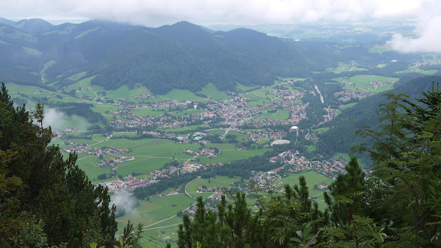
Well, we knew pretty much straight away that Rhupolding was a special place - the town sits close to the Germany/Austria border in what is known on the map as Upper Bavaria East.  We flew into Salzburg on 9th August and within 45 minutes were dropped off at our hotel.  The journey from Salzburg to Ruhpolding gave us some wonderful views of mountains like we have never seen and lovely Alpine houses.


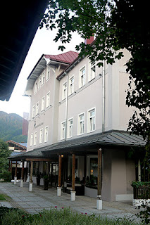
Our Hotel was situated in the heart of Ruhpolding and is family run - the current owners being 4th generation. We were hastily checked in and encouraged to dump our bags and head straight to the restaurant for dinner as they stopped serving at 9pm!


Whilst the food in the hotel has largely been fine - I have found that the food is heavy in salt and fat. German/Bavarian cuisine also doesn't cater much for the non-meat eater and as someone relatively new to eating meat I found some of it quite challenging though I gave most things a go! Dishes like leberknodle soup (a clear beef broth with a liver dumpling) or hog roast (offering everything from pork knuckle and pork belly to sausage). The food that was delicious came from the local bakery - the Schuhbeck.  The Schuhbeck was an absolute delight for the eye with approximately 50 different types of rolls and bread, about 15 different cakes and very tasty sandwiches.  I would say that that place alone is responsible for me putting on a couple of pounds!


The weather on our first week was glorious, hitting 35 degrees on some days.  The second week was a bit cooler but mostly dry and we got out for walks every day (with the exception of the Sunday after we arrived which was a chill day to wind down from work and another day for just relaxing in between walks/excursions).  In the two weeks we have been here we have walked many miles and climbed great heights!


Ruhpolding is nestled in the Chiemgau region in the Alps with a population of approximately 6,800. It is certainly geared to those who like activity holidays.  It has hosted the Biathlon World Championships four times and in the winter is home to those with a love of winter sports.  There are in excess of a hundred hiking routes in and around the area with many suitable for cycling.


The town is immaculate. There is no litter, the local flower beds are mainly wildflowers and the local houses and businesses are decorated with colourful hanging baskets and meticulously painted murals. The residents' gardens are also well maintained and you can tell there is a real pride in the town. Even 'tourist avenue' (as our Thomson rep described it) is tasteful - not offering the usual tourist tat you normally find but lovely linen and handmade wooden gifts (not cheap mind you!).


There are various bronze sculptures dotted around - some celebrating the Bavarian connection to wood cutting and one showing two children with a pretzel!  Yum!

The local river, the Traun, was crystal clear - I've never seen river water like it and we were told the drinking water in Bavaria is the best you will get anywhere.  Walking around there are loads of water fountains for you to take quick refreshment.  The dozens of Alms dotted around the hills also offer really tasty local dishes and beer (or water if you are so inclined!).  I couldn't fault the place at all - it is known for being wet (on average 20 days in the month of August are wet) but we were lucky with only one really wet day.

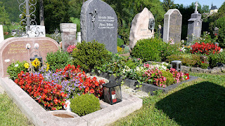
There is a strong Catholic faith here.  The local church (St Georges) sits just above the hotel with a view right across Rhupolding.  On our travels we have passed numerous private places of rest/memorials - all tended with great love and care.    The cemetery is of the like I have never seen before - the headstones more a work of art than the standard stones you get in the UK and the grave itself planted out with a colourful selection of plants (again very well cared for).


One thing it is short on is bird life. I'm not sure if that has been to do with the heat but we haven't seen many birds.  What we had plenty off was butterflies and dragonflies and the fields are alive with the sound of crickets and grasshoppers - which was lovely given they are so rare in our part of Scotland as it is so wet! We've seen the odd sheep and the odd goat but apart from that it tends to be cattle that is kept by the local farmers.... and no pigs, which is surprising as the Bavarians eat a lot of pork!

Blair also had wood envy. Nearly every house has a ready supply of chopped and well stacked wood, obviously in preparation for the winter. Walking through the woods we encountered huge trees that had been logged ready for chopping and splitting.

The hillsides were also covered in lovely Alpine flowers - no bracken anywhere!


Friday, 21 August 2015

Laubau to Rhupolding (via Rauschberg)

Well, we did it!!


Our final full day and we've ended on a high (no pun intended!).

We started our walk at Laubau, a short bus journey out of Rhupolding and home to the Wood Cutters Museum we had visited earlier in our holiday.

From there we followed the path up (and up) to Rauschberg - which I've mentioned previously is the local highest peak. There are many other peaks we haven't done and we'll save those for next time as WE WILL BE BACK!


We have woken up to Rauschberg every day - it has been an imposing sight at 1671m/5482ft.  Rhupolding sits at 660m/2165ft above sea level so we are already pretty high up.  The path up was a mixture of forest road and woodland path, slippy in parts due to the clay soil.


On the way up we passed several other walkers and a group of nordic walkers who then passed us and remained ahead of us for the rest of the climb - in fact we never saw them again so they must have just headed back down the other side (or taken the cable car!).


When we reached the cable car station (27m/88ft below the actual peak) there were a fair number of tourists dressed in their nice clean walking gear who had clearly cheated and taken the easy way up - you could tell by the footwear! There were some views down to Rhupolding but we didn't get the famed 360 degree views due to the low cloud.


We carried on for the last 88ft to the peak which was a bit of an anti-climax. We had no views whatsoever but there was no way we were going to walk this far and not reach the actual summit.


Back down at the cable car station we had some lunch in the restaurant - coffee and a local speciality called Kaiserschmarn which is a pancake filled with fruit and served with apple sauce (it was the only thing we could decipher from the menu!).  The climb to the peak was 5.6miles/2hrs 39min.

It was now time for the walk down, which was a different route to that we took up as this one took us to Rhupolding.  The path down was very steep in parts and cut through Rauschberg and Streicher (1594m/5229ft) with views over to a much larger, stonier range of mountains including the impressive Sonntagshorn (1961m/6433ft).


The path was a bit punishing on the legs and feet but we got some great views we hadn't appreciated climbing up and we had a good view of Rhupolding in the valley - we could also see Lake Chiemsee in the distance.  The path brought us out at a caravan site and we joined the path next to the River Traun which took us back into Rhupolding - this leg of the walk being 7.5miles/2hrs 25mins.

We arrived back to the Hotel very tired and in need of a hot bath to ease our tired feet.  The sun is shining and it's due to be lovely again tomorrow - we'll be happy to get home but we will miss the relaxation of Rhupolding (relaxation being a strange word to use I suppose as we have been out walking practically every day!).

Total climb - 13.1 miles/5hrs

Thursday, 20 August 2015

Unternberg Peak

We caught the 9:25 bus to Seehaus and started our hike to Unternberg around 9:45 - our plans to climb Rauschberg once again foiled by the weather. Not that the weather was bad or anything - just the low cloud meant that the hill had disappeared from view and (I felt anyway) that the 1000m/3280ft climbing effort would be in vain if we couldn't even appreciate the well renowned view from the top!

For the first 2.5 miles on  forest track, we continually climbed up...


and up...


and up...


and up!

The last half mile was on an extremely slippy clay mud path (which made me grateful we were going up as opposed to down as that would have made for an interesting slide!).


After that steep 2.5 mile climb the path levelled off just a bit and we walked the last half mile or so on to the Unternberg Alm where we stopped for coffee.  Despite the low cloud of the morning there were half a dozen keen enthusiasts waiting to paraglide off the top of the peak - we later saw a couple in mid flight when we were part way through our descent.


The Alm itself was really cosy inside and I could imagine very welcoming on a cold winters day.  The heavy wooden chairs had sheepskin rugs on them and there was a stove in the corner in the shape of a whisky barrel.


There is a chairlift which takes you from ground level to the top of the hill (which we would have got free with our guest extra card).  I checked it out on the way back down and decided that I wouldn't be able to do it - my fear of heights is just too much!


We were surprised how little time the walk took us. We didn't follow the suggested route which would see us taking the same way back as we came (indicating a 10.6k/6.6m distance with a time of 4.5 hours) but took a route which allowed us a walk back to Ruhpolding as opposed to waiting for the bus. Walk: 8.3 miles/3.5 hours and we reckon a climb of around 2,300ft.

Wednesday, 19 August 2015

A wander through the woods to reach the Cow Bell forge


Well, we had planned to walk up Rauschberg today but the weather wasn't particularly good and the forecast for the day didn't look promising.


Instead, we decided to venture out and walk the long way round to the Glockenschmiede (the Cow Bell forge - where I had hoped to buy a cow bell).

We started the walk by walking up past St George's Church and then following a path to Brand - within a mile we had lost the signpost for Brand and we ended up doubling back on ourselves, essentially walking a 2 mile circuit!


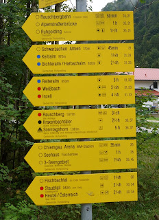
We looked at the map again and eventually found the path we needed and started again, climbing up a main road until we found the way marker for Hochfellan (1674m/5492ft) which we need to follow for part of the way. According to the map there were some minor/unmarked paths that we should have been able to follow to get us to the forge but we couldn't find them (despite three failed attempts and a fair amount of climbing and then descending).

The path was through forestry which gave us some shelter from the rain but afforded very little in the way of views.  We retraced our steps back to the way-marked route, given that we had no other option but to go the long way round and we continued to undulate on the forest track before eventually coming out at the forge.

Stepping into the forge was stepping back in time - from the outside it looks like a simple alpine house but in the inside it is full of old tools  (the smithy also produced a large number of tools such as straw knives, scythes, sickles, axes, logging tools, bark cutters and turf knives - many of which were on display).  Inside there were three ovens and three mini waterwheels which powered a hammer-like tool.


We watched a film (in German) which showed the forge working in 1955 and we later learned that the forge is referenced by the Ruhpolding Parish as far back as the 17th century.  The workshop and it's two water wheels are listed and the water wheels looked very delicate.


The wee shop (nothing more than a shed) offered a fair variety of cow bells for sale and we treated ourselves to one before heading back onto the path for Rhupolding.  As we had been walking for a fair number of hours and hadn't eaten lunch we headed straight to the Shubeck for cake and coffee!  Worth saying that we did a fair amount of climbing and I certainly feel that we climbed the equivalent distance of Rauschberg - we reckon we climbed in excess of 1293m/4242ft).

Walk:  13.5miles/5.5 hours